한국전쟁과 주한미군 (7)
fabiano
한국전쟁
0
2614
2013.04.25 10:44
Maps of the Korean War 1950-1952 (2)
아래 지도는 한국전쟁 당시 美軍이 작성한 지도로서 1950. 6. 25. 개전 당시 부터 중공軍이 개입하여 미국戰史에서도
가장 치열했던 美 해병1사단의 장진湖전투에서 흥남 철수작전까지의 상황을 한 눈에 볼 수 있는 귀중한 史料이다.
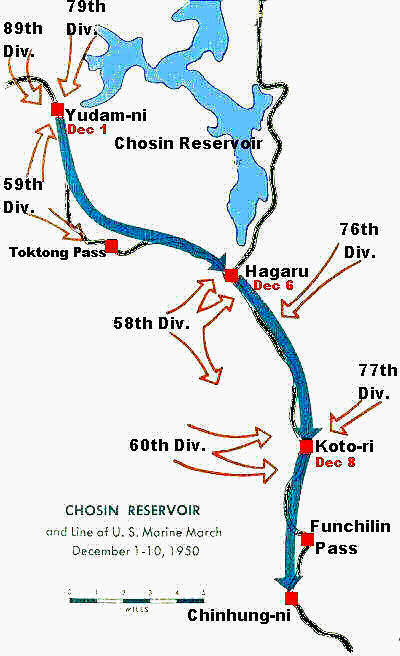
Marines and Chinese Forces in Chosin Reservoir(장진湖) Area
Distances North to South
Yudam-ni to Hagaru-ri ------------ 14 Miles
Hagaru-ri to Koto-ri -----------------11 Miles
Koto-ri to Chinhung-ni ----------- 10 Miles
Chinhung-ni to Sudong ------------ 6 Miles
Sudong to Hamhung -------------- 29 Miles
Hamhung to Hungnam ------------- 8 Miles
Total ------------------------------------ 78 Miles
Hagaru-ri to Koto-ri -----------------11 Miles
Koto-ri to Chinhung-ni ----------- 10 Miles
Chinhung-ni to Sudong ------------ 6 Miles
Sudong to Hamhung -------------- 29 Miles
Hamhung to Hungnam ------------- 8 Miles
Total ------------------------------------ 78 Miles
The 59th, 79th and 89th Divisions had been effectively put out of the fight. However, the 58th, 60th, 76th and the 77th Divisions composed of 40,000 men in the hills commanded the 21 miles between Hagaru and Chinhung-ni.
The road begins at Hungnam. From Hungnam to Hamhung is 8 miles; from Hamhung to Sudong 29 miles; from Sudong to Chinhung-ni 6 miles; from Chinhung-ni to Koto-ri 10 miles; from Koto-ri to Hagaru 11 miles, and from Hagaru
to Yudam-ni 14 miles.
Not a mile was easy. Narrow and winding, oxcarts had a hard time passing, let alone tanks, trucks and artillery.
Dirt and gravel constituted most of the road. At times it seemed to go straight up; at other times straight down.
It went from low country to towering peaks.
The most difficult was Funchilin Pass, a slow, steady climb of eight miles to the high country, 2,500 feet up to Koto-ri.
North of Koto-ri the road runs into a high plateau, then continues on to Hagaru, most of which had been flattened by bombing. Above Hagaru, at the southern tip of the Chosin Reservoir, the road climbs and winds up to Toktong Pass,
4,000 feet high, then drops into Yudam-ni Valley. There it splits, one route continuing north, another west.
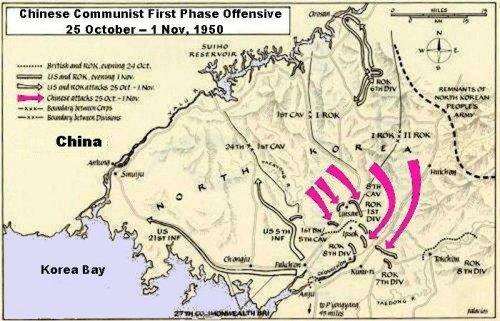
Map of Chinese First Phase Offensive
25 Oct. - 1 Nov. 1950
25 Oct. - 1 Nov. 1950
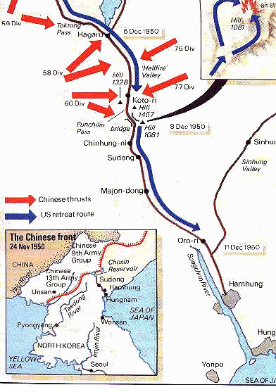
Map of The Withdrawal to Hamhung, North Korea
This map illustrates the withdrawal of the UN forces along the MSR to Hamhung and
then the the port of Hungnam.
It also shows the major attack forces of the Chinese and the Chinese divisions
involved in their attacks.
My company withdrew on the road shown in the upper right side after being released by the Marines.
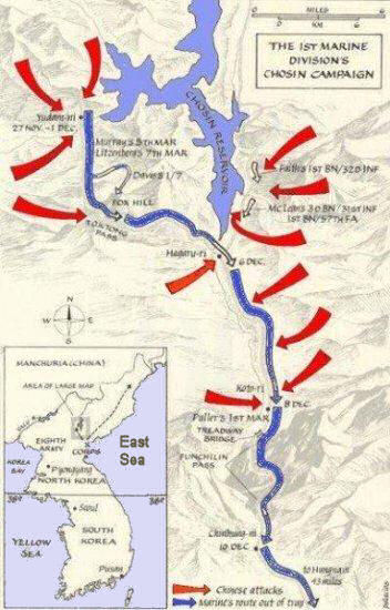
Map of X Corps and Chinese Forces in Chosin Reservoir Area
The Chinese faced a number of formidable obstacles. First was the determination of the 1st Marine Division.
Secondly, the fierce cold. While it hindered the UN forces the Chinese were far less equipped the fight the cold.
Cotton uniforms and canvas shoes contributed to the Chinese lack of success, Lack of communications hampered
the Chinese efforts.
Lastly the tactic of attacking each of the Marine and Army locations all at the same time diluted their numerical superiority.
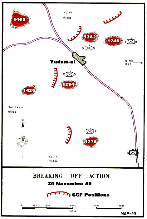
Yudam-ni Breakoff - Nov. 30 1950
The breakout required the Marines to control some of the hills along the breakout.
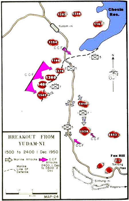
Yudam-ni Breakout - Dec. 1 1950
This was the beginning of the breakout from the Chinese encirclement.
It was inperative for the defense of Hagaru to be reinforced by the troops from Yudam.ni.

Yudam-ni Breakout - Dec. 2-4 1950
This map shows the objectives and tasks assigned to the 1st, 5th, and 7th regiments the 1st Marine Dicision.
Success depends on each doing their job well.
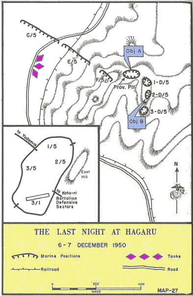
Last Night at Hagaru - Dec. 6-7 1950
Success of the breakout strongly depended on control of the hills surrounding the town. A very important part was the construction of the airstrip in both bringing in supplies and evacuation of wounded.
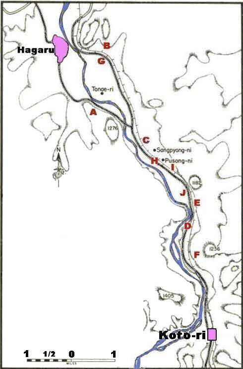
Hagaru Breakout 6-7 Dec 1950
A -- 1/7's Initial Objective
B -- CCF Position Overlooking the MSR
C -- 2/7 Held up by CCF Machine Guns
D -- Blown Bridge
E -- 3/7 & Regimental Train Held Up
F -- Commandos Rescued
G -- 3/11 Firefight
H -- Division Train Held Up
I -- Pusong-ni
J -- Hell-Fire Valley
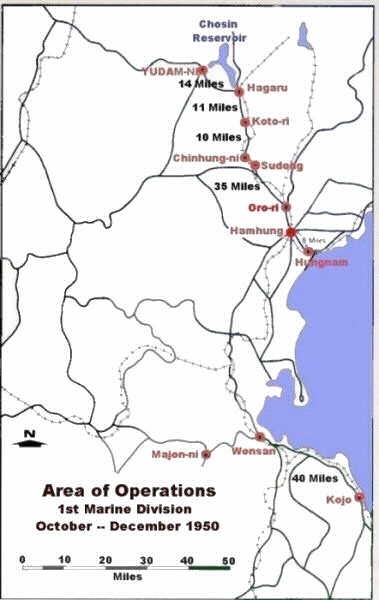
Map Marine Area of Operations
Oct. - Dec. 1950
Oct. - Dec. 1950
This map gives you a better overall view of the entire area of operation in North Korea.
My team unit of the 581 Signal Radio Relay Company had its relay station some 100 miles north
on the road leading up and the right at the top of the map.
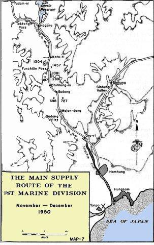
Map Military Supply Route (MSR) 1st Marine Div
The main locations of 1st Marine Division were (from North to South) Yudam-ni, Hagaru, Koto-ri and Chinhung-ni.
Most of these cannot be found on many maps because they are mostly insignificant small villages mad famous
by the Marines in their withdrawal.
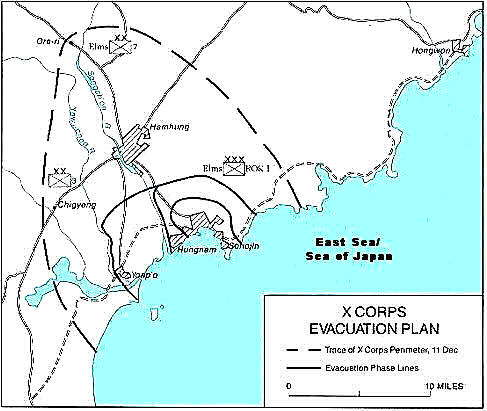
X Corps Evacuation Plan from North Korea
This shows the plan for an orderly withdrawal from North Korea by X Corps. The Communist forces had been
so mangled that they were unable to mount a strong attack on the disembarking UN forces.
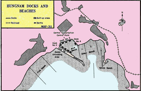
Map Showing Hungnam Docks and Beaches


