한국전쟁과 주한미군 ⑥
fabiano
한국전쟁
0
3419
2013.04.23 13:41
Maps of the Korean War 1950-1952(1)
아래 지도는 한국전쟁 당시 美軍이 작성한 지도로서 1950. 6. 25. 개전 당시 부터 중공軍이 개입하여 미국戰史에서도
가장 치열했던 美 해병1사단의 장진湖전투에서 흥남 철수작전까지의 상황을 한 눈에 볼 수 있는 귀중한 史料이다.
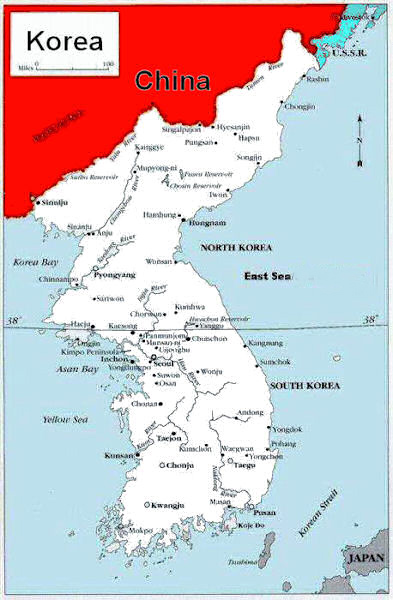
Map of Korea
Map of The Furthest Advances by North Korea and China
A Seesaw War
The North Korean invaders pushed the South Korea and American reinforcements south to Pusan.
1 Landing at Inchon
2 UN troops counterattacked and drove toward the Chinese border at the Yalu River.
3 China came to the aid of the North Koreans and forced the allies back to South Korea.
4 Finally, another American and UN counteroffensive pushed the Chinese and North Koreans north to the 38th parallel.
5 Thus it ended about where it had begun.
Dates and Activity
1 Pusan Perimeter (August 5-September, 1950)
2 Inchon Landing (September 15, 1950)
3 Northern Line (November 24, 1950)
4 Southernmost Advance (January 24, 1951)
5 Approximate Line during Armistice Talks (June 15, 1951)
6 First Marine Division from Kobe, Japan
7 Seventh Army Division from Yokohama, Japan
8 Fifth Marine Regiment from Pusan, Korea
9 MacArthur's Command Ship, Mt. McKinley from Sasebo, Japan
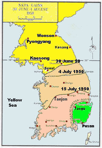
Map Showing NKPA (North Korean People's Army)
Maximum Gains
Maximum Gains
After the initial attack by the North Korean Army this shows the withdrawal by the South Korean Army and US army forces. Denied any tanks and artillery they were helpless against the better equipped North Korean military.
Dates are shown to indicate how rapidly the offensive took place.
It amounted to delaying the North Korean enough for better equipped UN forces to be sent to Pusan.
Things turned around after the 5th Marine arrived in Pusan.
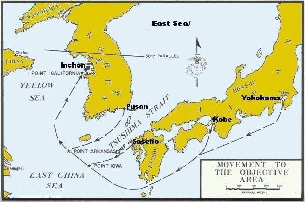
Map of Inchon Invasion Task Force Routes
This map shows the groups that participated in the landing at Inchon.
Various groups came from Kobe, Sasebo and Yokohama Japan.
My Company came from Yokohama.
The 5th Marine Regiment who had saved the day in Pusan joined the group from Pusan.

Map of Inchon Assault Plan
This shows the plan for taking Inchon. It was complicated by the 30 foot tides that come and go at Inchon.
That plus formidable sea walls that surrounded the beach. However, surprise helped the UN forces.
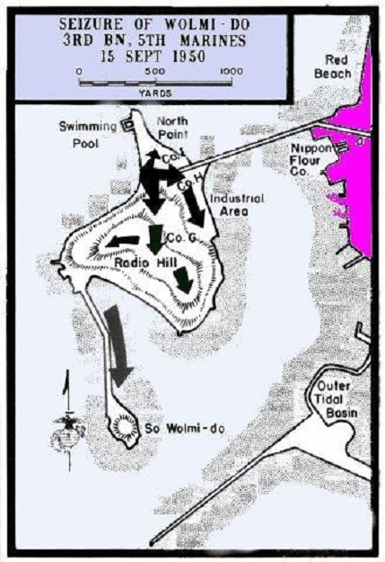
Map Showing Wolmi-do Island in Inchon Harbor
In the invasion of Inchon it became a priority to clear North Korean troops from Wolmi-do Island. After the successful attack the Marine would have to wait until the next turning of the tide to move on to the mainland along the causeway.

Map of Inchon Seoul Area
A map that gives you a better perspective of thew Inchon/Seoul area.
Kimpo airfield was an important objective and served as an excellent base for UN air operations later.
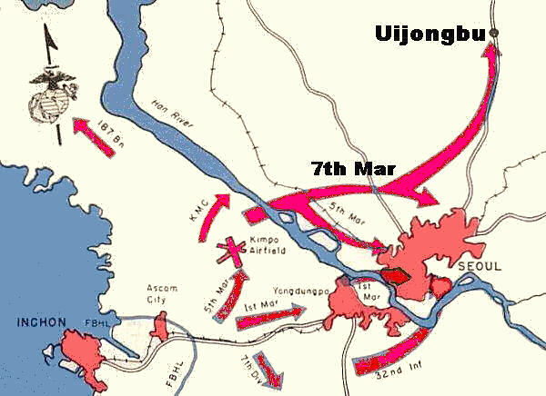
Map Showing Inchon - Seoul Battle Plan
After Inchon had been secured the Marines and Army units then moved on to Seoul to take the capital. The 7th Marines who had arrived later moved out to take the Uijongbu area.
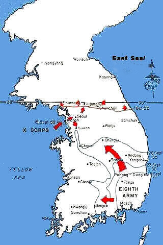
Map of Korea Offensive - Sept 15 - Oct 1
This map indicates the breakout of the UN forces from the Pusan perimeter.
This was after the successful invasion at Inchon.
My unit, the 581st Radio Relay Company entered the war at the Inchoin invasion.
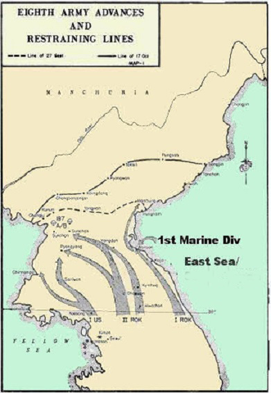
Map Showing Eighth Army Advance, North Korea.
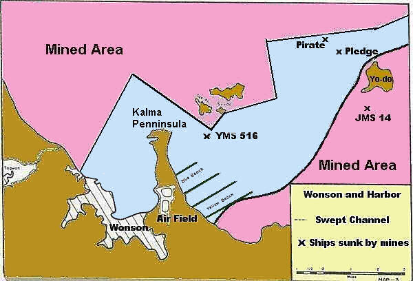
Map Showing Wonson Harbor
This map shows the area cleared of mines for the landing of troops into Wonson.
Three minesweepers were sunk by mines during the mine clearing operation.
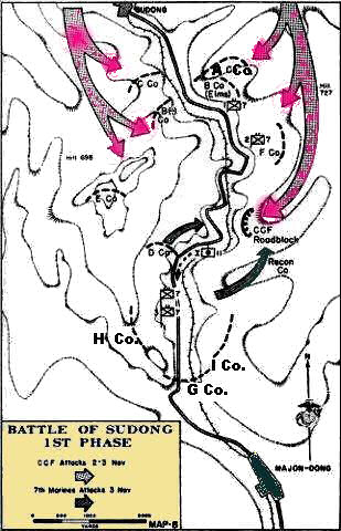
Map Showing Sudong Battle
In the battle of Sudong the Chinese 124th Division was badly mauled and rendered combat ineffective.
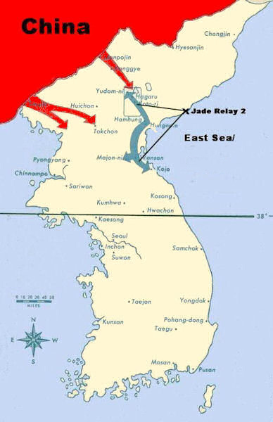
Marines and Chinese Forces in Chosin Reservoir Area
The 581st Signal Radio Relay Company had a stations at the Chosin Reservoir with the Marines.
My station, Jade Relay 2, was on the coast at the point indicated by the X.
We fed south to Wonson and west to Koto-ri.
The Army picked that spot at Jade 2 because we had a straight shot to Wonson.
Our transmitters, only 50 watts and FM, normally has an outside range of 50 miles.
Over water the beam tends to bend and it was successful.
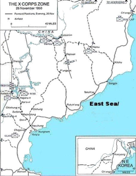
Map of X Corps Zone in North Korea
This map shows the overall area facing the X corps. Note the few roads.
Most of them are unpaved and single track.
In addition they are in poor condition.
Many are not suitable for heavy transport.


